 National Capital District (NCD)
General Information Administration Provincial headquarters: Port Moresby Number of electorates: 3 - Number of LLGs: n/a Number of wards: 12 About National Capital District The NCD is the administrative unit that encompasses the national capital of Papua New Guinea, Port Moresby. While the administration of NCD is quite different to the Provincial Governments, for electoral purposes, is classified as the equivalent of a province, in that it has a Provincial Member, who becomes the Governor of the district. The NCD is separated into three open electorates, however these are not considered districts in the same administrative sense as the other open electorates of Papua New Guinea, due to the wide-ranging authority of the National District Capital Commission (NCDC). The National Capital District Commission (NCDC) is the administrative authority and operates under the National Capital District Commission Act. This law establishes the NCDC a governing body for the purpose of providing municipal services to the entire city.
The provincial member is Mr. Alphonse Moroi, of the Rural Development Party. This is his second term.People living near Bereina can earn a high income from the sale of food and betel nut, while those in reasonable proximity to Port Moresby can earn moderate incomes selling food and other goods at markets. People in the more remote areas of Goilala and Abau have low potential environments and earn low incomes. Many people commute to earn non-agricultural wage incomes in and around Port Moresby. A road runs along the length of the province, and areas around Port Moresby are also well served by roads. Another road leads up to the Sogeri Plateau and the start of the Kokoda
Track. However, Goilala district and the east of Abau district have very few roads. 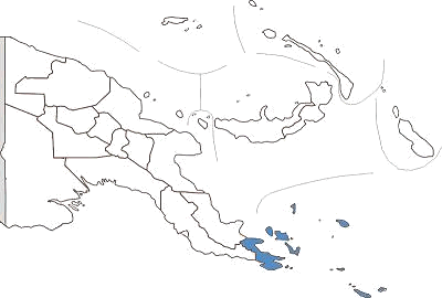 Milne Bay Province takes in the land at the extreme eastern end of Papua New Guinea together with seven groups of islands, the Trobriand, Woodlark, Laughlan, Louisiade Archipelago, the Conflict Group, the Samarai Group and the D'Entrecasteaux Group. The names come from a variety of explorers from as early as 1660 when D'Entrecasteaux sailed through and left his name behind. Over the years, missionaries, miners, and traders in pearls, scientists and Japanese and American warships have visited Milne Bay Province. During the war Milne Bay became a huge naval base through which hundreds of thousands of servicemen passed. Today thousands of tourists arrive to enjoy diving around the wreckage left behind from the war. There are 160 named islands and 500 cays and atolls scattered over 250,000 square kilometres of ocean. In many parts of Milne Bay, the reefs are characterised by dramatic drop-offs, clefts and overhangs. The most comfortable way to enjoy Milne Bay diving is aboard one of the liveaboard dive boats based out of Alotau, the provincial headquarters. The 60 foot MV "Chertan,' can comfortably accommodate up to 14 divers. Built in 1992, it is equipped with the latest electronic equipment, video and stereo systems. The MV "Telita" was Papua New Guinea's first live-aboard dive boat and was designed specifically as a live-aboard diving vessel. It has five twinberth abins; sophisticated electronic equipment, a bar, video, stereo, a well equipped library and a charging console for photographers. Alotau, spectacularly sited on the edge of Milne Bay is a good base for visiting the outlying islands. Fergusson Island has an active thermal region, hot springs, bubbling mud pools, spouting geysers and volcanoes. Misima Island was the scene of a 1930's gold rush from which a major mine has now been developed. Woodlark Island is populated by people of Melanesian ancestry. The islanders are renowned for their expertly crafted wood carvings. One of the best locations to enjoy the charms of the friendly and peace loving Milne Bay people is the Trobriand Islands. Their unique social system is dominated by hereditary chieftains who continue to wield tremendous power and influence, although inheritances and lines of power are passed through the female side of the family. From June - August the Milamala yam harvest festival is held. The Milamala starts with a procession of men carrying the newly harvested yams from the garden storage hut to the village yam houses while the women ahead sing and dance. During the festival time, traditional rites are observed, It was from Malinowski's anthropological studies of the customs and sexual practices during this time that The Trobriand's became known as "The Islands of Love". The Trobriand Islanders will offer for sale their beautifully carved walking sticks, figurines, fish and turtle-shaped bowls made from local timbers including the much sought after ebony. Fresh water caves are found all over Kiriwina Island, Near Matawa Village there are several deep limestone caves housing burial antiquities and skeletal remains. At Wawela there is a beautiful curving beach on a cool, deep lagoon. The village children fishing from their outrigger canoes are happy to give visitors a ride out to the reef to enjoy snorkelling. Visitors should bring their own snorkel or dive gear to Kiriwina as availability at the lodges is not constant.  Milne Bay Province
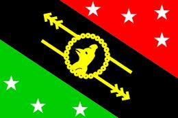
General Information Administration Provincial headquarters: Alotau Number of districts: 4 - Number of LLGs: 16 Number of wards: 394 About Milne Bay Milne Bay Province covers the southern tip of Papua New Guinea's mainland, from the end of the Owen Stanley Ranges to the coastal plains, as well as many small and large island groups in the Coral and Solomon Seas. While people near Alotau and in the Trobriand Islands can earn moderate incomes from fish, food and betel nut, the rest of the province earns low incomes. Oil palm provides some income, however, the closure of Misima Goldmine has reduced incomeearning opportunities. Good roads service the provincial capital of Alotau and run to North and East Capes as well as inland, however, areas on the southern and northern coasts of the mainland remain quite isolated. The islands rely predominantly on dinghy and canoe transport and some commercial and passenger shipping. Only Kiriwina Island has serviceable roads. Over a day’s travel is needed from the more remote islands to reach a service centre.  Few people would expect to find fjords in Papua New Guinea. The Tufi area on the south east coast of Oro Province is one of PNG's best kept secrets. Situated on Cape Nelson, Tufl is a spectacular place to visit. Cape Nelson, jutting out into the Solomon Sea, was formed by the eruption of three volcanoes, whose fast flowing lava created the rias, or fjords. Unlike the fjords of Scandinavia, the water is always warm and the sheltered bays are home to stunning coral formations and tropical marine life. The fjords are over 90 metres deep and rise vertically out of the water to over 150 metres. Wide entrances are protected by reefs and they funnel into the mountainside where mangroves form a canopy over narrow waterways. The vertical faces of the gorge are covered with moss and orchids and waterfalls cascade directly into the sea. Although the main attraction is diving, there are plenty of options at Tufi bushwalking, deep sea fishing, windsurfing, swimming, canoe trips or just lazing on the white sandy beaches. Wander among the villages or go to the open market and see the handcrafted pottery, jewellery and tapa cloth that are typical of the region. Tapa cloth is made from the beaten bark of the paper mulberry tree and decorated with exotic designs in natural earth colours. In October every year there is a Tapa Cloth Festival. Other festivals held locally are Martyrs Day and the Korata Church Day. The province is also the home of the largest butterfly in the world, the Queen Alexandra Birdwing, which has a wingspan of 30cm. With the diminishing rainforest, this species is unfortunately fast becoming extinct. There are a number of village guest houses which offer comfortable accommodation and will arrange fishing, diving and coral viewing excursions. The Tufi Dive Resort, perched on the side of a fjord has mountain views up and out to sea. It is constructed of bush materials and decorated with carvings and artefacts from around the country. Oro Province has a history of drama, from the early gold rush days to the devastating Pacific campaign of World War 2. The northern end of the Kokoda Trail terminates at the village of Kokoda and from here to the coast, and around the beaches of Buna and Gona, some of the most violent and bitter fighting of World War 2 took place. It is estimated that over 15,000 Japanese soldiers died on the Kokoda Track. The area is still littered with war relics and at jiropa Plantation on the Buna Road, there is a Japanese plaque commemorating their dead. Not long after the war Mt Lamington erupted, wiping out the district headquarters at Higaturu and killing nearly 3,000 people. Today the provincial capital is located a safe distance from the volcano, at Popondetta. Mt Lamington is a favourite climb for bushwalkers. There are road links between Popondetta, Tufi, loma, Kira, Kokoda and Afore with PMV buses travelling regularly between the districts. Oro Province is served by Air Niugini, Airlines PNG and other third level airlines, with flights to Popondetta and Tufi. 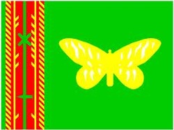 Oro Provincial Flag Oro Provincial Flag General Information
Administration Provincial headquarters: Popondetta Number of districts: 2 - Ijivitari, Sohe Number of LLGs: 9 Number of wards: 162 About Oro Oro Province covers the northern side of the Owen Stanley Ranges and a stretch of coastline from Cape Ward Hunt in the north to Collingwood Bay in the south. It includes the village of Kokoda near the eastern border with Central Province, as well as Cape Nelson and the coastal fjords near Tufi on the coast. High incomes can be earned in the Kokoda Valley from oil palm, cocoa and fresh food. More moderate incomes from oil palm can be earned near the coast. Some wage employment is also available in Popondetta. Elsewhere in the province incomes are very low. A road runs from Popondetta to Kokoda and another to Afore. Otherwise there are very few roads in the province. Coastal communities rely on dinghy and canoe transport. Very remote communities in this province must walk long distances over mountainous terrain to reach roads that continue to service centres. 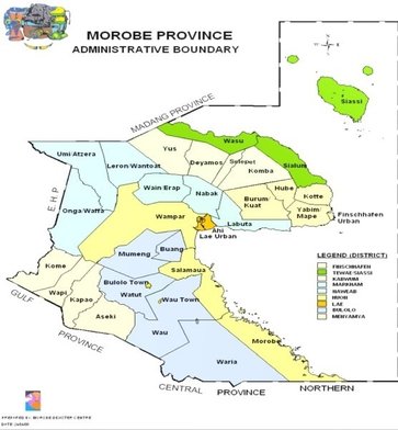 Morobe Province is located on the North Eastern part of Papua New Guinea. The Province is on northeast coast of Papua New Guinea takes its name from former German capital Morobe, southeast of the present provincial capital, Lae City.
POPULATION The Province with a population of approximately 500,000 is divided into nine districts Bulolo, Finschhafen, Huon, Kabwum, Lae, Markham, Menyamya, Nawaeb, Tewae/Siassi and; 230 distinct languages are spoken. BORDER The province shares common boarders with Madang, Eastern Highlands, Gulf, West New Britain, Central and Oro Provinces. Lae is the center of PNG and is the provincial capital and the second largest city in the country. It is situated at the mouth of Markham River and the start of the Highlands Highway. The Markham river valley runs through the center of the province. The province is characterized by rough terrain to gentle slopes and flat plains. The main mountain chain includes the Huon Peninsula, Sarawaged with the highest point (at 4,425 m above sea level) the Rowlinson range to the north and the Owen Stanley Range to the South. GEOGRAPHY The major river system includes the Markham and the Waria rivers, which are two of the ten fastest flowing rivers in the country. The other notable rivers that have potential for hydroelectric scheme development are the Watut, Mongi, Masaweng, Paiawo, Maiama and Franscisco rivers. The climate is and extremely humid as a result of high mountains and deep valleys. More than 5,080 mm of rainfall is recorded annually in Lae. The provincial map above shows main centres of the 9 major districts in the Morobe Province. LAND The total landmass including the sea area of the province is 34,650.6 square kilometres which is the largest in PNG. The total land area is 33,931.6 square kilometres and the maritime area is 719 square kilometres. The province can be grouped into three main geographic areas, namely the coastal, island and mountain areas; and finally, the river and valley areas. The coastline of the province extends to approximately 402km from the south and southeast to the north and northeast. Lae is the main industrial centre in the country, and is vibrant with many different commercial activities. It serves as the distribution port for all Highlands provinces including Madang for imported merchandise. A new Tahiyo Cement Factory was opened in 1993 and two fish canneries were opened since 1996 to add to the many industries, which have flourished over the years in Lae providing many employment opportunities to the people. The current development of Malahang Industrial Centre will open up more opportunities for new businesses to start. Other industries operating in Morobe Province include mining, especially in the Wau and Mumeng areas, timber, fishing, and tourism. Gold and timber are Morobe’s leading exports. ECONOMY Whilst Morobe boasts a great economic potential, it is still very much underdeveloped for a number of reasons. Firstly, it is dominated by the exploitation of primary products, such as agriculture, forestry, and mining and to a lesser extent fishing. Agriculture remains the dominant sector. There are three types of agriculture production namely, traditional subsistence, smaller holder cash crop generating and large-scale plantations. (Adopted from Morobe Provincial Population Action Plan 2005-2010 p5) About 452.3 hectares of land throughout the province is under cultivation by subsistence (farming) agriculture; coffee is the largest cash crop followed by cocoa, cardamom, coconut, rice and chillies. Livestock development is dominant in the rich Markham Valley with some development in the Wau and Bulolo District. Forty percent (40%) of the country’s beef supply and the country’s largest chicken production are in Morobe. There is also large-scale crocodile farming in the province. Morobe is experiencing an increase in hotel development and tourism industries. Districts
Provincial Capital is: Lae (second biggest city in PNG) 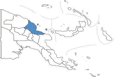 The most popular location in Papua New Guinea for divers, Madang Province consists of reef-fringed lowlands backed by some of the most rugged mountains in Papua New Guinea and offshore volcanic islands. Colourful Madang township has been called the "prettiest town in the South Pacific". It's peninsula setting is a show-place of parks, waterways, luxuriant shade trees and sparkling tropical islands. Although small, the town has modern urban facilities, including hotels, department stores, markets and artifact shops. There are five hotels in Madang - The Madang Resort Hotel, Smugglers Inn, Jais Aben Resort, Malolo Plantation Resort and Madang Lodge Motel, all of which provide excellent facilities. There are a few budget guesthouses and lodges around Madang and some small village guesthouses on several of the islands on Madang lagoon. The area is world famous for its coral reefs and superb visibility making diving good all year round. There is a variety of easily accessible places to dive, an abundance of reef and pelagic fish, dramatic drop offs, shells and soft and hard corals. Those who like diving on wrecks will find the reefs liberally dotted with sunken ships. Hansa Bay, the resting-place for at least 34 Japanese ships, is within striking distance up the coast. Ships lie in shallow water and are now covered in corals and fish. Jais Aben Resort, just outside Madang, is a combination research station and resort hotel specially catering for divers. Diving instruction in Madang is available at Jais Aben Resort, Madang Resort Hotel and Smugglers Inn. Game fishing is a popular sport and the coastal currents around Madang Province carry sailfish, kingfisher, tuna, mackerel, barracuda, marlin, yellow fin and wahoo within 100 metres of the shore providing anglers with plenty of good sport. Fishing is especially good off the waters around Karkar and Bagabag islands. The two volcanic islands of Manam and Karkar have volcanic cones rising 1800 metres above sea level and provide a spectacular sight for visitors. A variety of local markets sell artifacts, shell jewelry, carvings and pottery. Tours can be arranged to visit the nearby villages of Bilbil and Yabob to see traditional clay pots being made or you can explore Madang Harbour with a morning harbour cruise. The South Coast road leads to the Balek Wildlife Sanctuary, which has strange fish-filled sulphurous caves, jungle walks, and hot springs. The Sanctuary was also location for filming scenes in the Pierce Brosnan movie "Robinson Crusoe". Madang hosts the Mabarosa Festival each year, a colourful display of dancing, singsings and bamboo bands. Papua New Guinea's largest tour operator, Melanesian Tourist Services (MTS) is located in Madang. They operate the MV "Melanesian Discoverer" and the Madang Resort Hotel. The "Melanesian Discoverer' is a luxury 42 passenger catamaran operating scheduled cruises from Madang, offering five day Sepik River cruises and one week cruises to the Trobriand Islands in Milne Bay Province. Madang is serviced by daily flights from Port Moresby via Lae and the Highlands and has a number of locally based third level airlines servicing small airstrips in the province. Helicopter charters can also be arranged. Madang is also linked by road to Lae and the Highland provinces. District District Capital LLG Name Bogia District Bogia Almami Rural Iabu Rural Yawar Rural
 One of the world's largest waterways, the Sepik, snakes it's way through East Sepik Province. Dense rainforest covers the north coast and the mountains north and south of the river basin. Birdlife and rainforest creatures splash colour across the blue and green hues. Sepik fishermen in their dugout canoes wave to visitors on the great white catainaran, the "Melanesian Explorer", as it plies its way down the river taking passengers on a journey which will impress an unforgettable image of the magnificence of Papua New Guinea. The Sepik River often compared to the Amazon and Congo Rivers presents nature untamed and unspoiled. See it from the comfort of the "Melanesian Discoverer" or the " Sepik Spirit" a luxury twelve berth flat- bottom river cruiser. For the more adventurous, the Karawari Lodge on the Karawari River, south of the Sepik is a quality but very remote jungle tourism lodge, or spend some time in a guest house in the villages along the river. Wewak, with its palm fringed beaches is the main town of East Sepik. Not far from Wewak is Cape Worn, the site of the Japanese surrender where Lieutenant General Adachi signed the surrender documents and handed his sword to Major General Robertson on 13th September 1945. A war memorial marks the site and the wartime airstrip is still in place. Another memorial in town has been erected at the site of the Japanese war graves and nearby is the Japanese/ PNG Peace Park. Accommodation in Wewak, while not luxurious, provides adequate facilities as a base for day trips to one of the 15 islands off the coast of Wewak. Idyllic tropical islands become a reality when you travel by boat to Kairiru Island with its waterfalls and hot springs. Swimming and snorkelling are superb in these clear turquoise waters. Diving is simply spectacular. Virtually unknown and untouched, the waters and reefs display an abundance of sea life - turtles, sharks, manta rays, tuna, corals as well as sunken wrecks from World War 2. Further afield is Wuvulu Island. Acclaimed as one of the greatest dive sites of the world, Wuvulu rises straight up from an undersea plateau 2000 metres deep. As there are no rivers or creeks the water is uncommonly clear. There is a guest house on the island and dive equipment is available. Wet season is April to November. From September to January the unprotected beaches along the coastline bring surf-board riders from around the country and overseas to surf one of PNG's few surf spots. East Sepik's fertile environment is reflected in its rich cultural traditions. Crocodiles, birds, turtles and other wild animals feature in East Sepik artwork. Sepik carvers are world-renowned for their fine craftsmanship. The region's most famous artefacts are the woven fibre ceremonial masks used symbolically in the yam festivals. Jewellery, pottery and canework can be found in the village markets as well as hotel shops around town. Wewak has a pier for overseas and coastal shipping. With 32 airstrips, much of East Sepik is accessible by air and Air Niugini has daily flights from Port Moresby to Wewak. 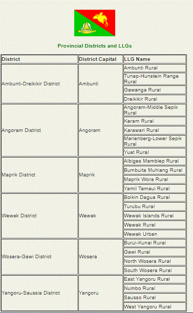  Vanimo, the capital of Sandaun Province, sits on a neat little peninsula with beautiful beaches on either side. A pleasant walk around the headland brings the snorkelling enthusiast to several good spots. To the west, wade past vine draped limestone headlands to reach the final resting place of a rusted Japanese landing barge. Vanimo, 30 kilometres from the Indonesian border is PNG's entry port from Jayapura in Irian jaya (formerly West Papua). This area of the world has seen little development in international tourism, other than visitors enroute from Irian jaya to other parts of Papua New Guinea, or the intrepid traveller or surfer in search of the perfect wave. Superb beaches west of Vanimo, towards Wutung, attract surf board riders from PNG and overseas during the months of September to January. The 260 kilometre shoreline is pounded by heavy seas caused by the blustery north west winds during December to March. However safe all-year round anchorage can be had in Vanimo. Several little islands lie offshore from the town of Aitape, the only other town in Sandaun Province. Aitape was established as a station by the Germans in 1905 and was occupied by the Japanese during World War 2. Bits of aircraft wreckage can be found near the wartime Tadji airstrip and a war memorial stands nearby. The headwaters of the Sepik River are in Sandaun Province. Here the river narrows into dense, mountainous country and only small boats can navigate upstream from the village of Ambunti. There are no roads in the Upper Sepik and much of the province is covered in rainforest. The villages here are known for their specialist religious cults. The people of Maio and Yessan have a yam cult and the isolated village of Swagup is the home of the insect people, whose art form incorporates the figures of the sago beetle, dragonfly, praying mantis and other insects. Among the distinctive artefact, from Sandaun are painted canoe, of Sissano Lagoon and large shields from the Telefomin district. The shields have broad zigzag, spiral or V designs that represent their ancestors' bodies. Vanimo has three hotels, the largest of which is the Sandaun Motel. In other parts of the Province village accommodation is available and some mission stations also offer simple accommodation. Air Niugini flies to Vanimo weekly en route to jayapura, Irian Jaya.   Bougainville is situated about 5 degrees south of the equator and is hot. Bougainville is going through a time of rapid change. Since the signing of the peace agreement in 2001 development agencies have been working on various projects from agriculture to business to improving health, education to name a few. North Solomons Province has two main islands, Buka and Bougainville plus a scattering of smaller islands and atolls. It is located north east of mainland Papua New Guinea. Blessed with a lovely French name shares with an explorer and one of the Pacific most beautiful plants, Bougainville is a jewel of the South Seas. And while a decade of disturbance has wilted the memories of some, the island is being reborn, and the business centre of Buka is booming. The North Solomons Province has been known for its picture-perfect beaches and bays since French explorers spread the stories of its beauty almost 200 years ago. The influence of the French is still found in the Polynesian languages spoken on the Takuu and Nukumanu islands. In fact 23 languages are spoken throughout the province. Almost a decade of civil war left only the language of violence until recently on the island of Bougainville. Now the fighting is finished and the lovely island of Bougainville is flourishing. Air Niugini can take you from Port Moresby to Buka three times a week aboard the swift and comfortable F28 jet services. Flights are scheduled for Tuesday, Thursday and Saturday, with the aircraft returning the same days. Number of guest house and a small island resort provide and, along with the market, a good range of shops will keep shoppers happy. Cafes and coffee shops make deliciously good use of local produce new the brand new hospital. Whether snorkeling or SCUBA diving, the waters off the coast are a treasure cove. A Visibility is almost unlimited, with wartime wrecks including a Japanese Zero aircraft only a few meters deep. The crafts and customs of Buka and North Bougainville are fascinating for anyone interested in the culture. Featured on the provincial flag is a tall hat, known as Upei. The Upei is a woven headdress worn by young men at their initiation and marriage ceremonies. Buka is the provincial capital. Shops and services for the town are located along the main waterfront, including the market and water taxis. Sohano Island is just a few minutes by boat from Buka, with its colonial buildings and manicured lawns and gardens. The steep cliffs provide fine views over Buka Passage and there are good swimming beaches. The volcanic island of Bougainville is covered in heavy jungle, and is home to one of the world's largest caves, Benua. The island's highest point is Mount Balbi (2685m), a dormant volcano. While roads, including the main road down to the east coast, are still being re-built, coastal shipping is still thriving between Buka and Kieta, near Arawa in the south. 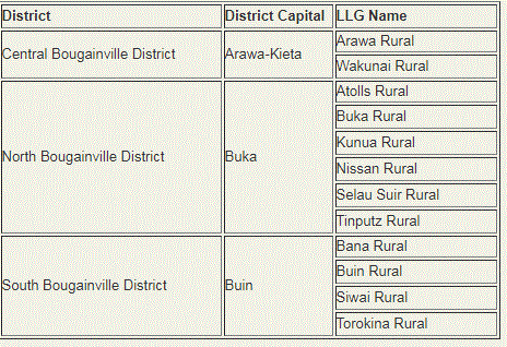  In contrast to the popular tourist destination of East New Britain, West New Britain is virtually untouched, unexplored and unknown. The exception is Walindi Plantation Dive Resort, a favourite destination for divers from all parts of the world. The Resort is located on a privately owned oil palm plantation on the shores of Kimbe Bay. The Bay is fringed by volcanic mountains, some still active. Divers can explore volcanic caves draped in staghorn coral and reef drop-offs. The clear blue waters are home to dogtooth tuna, trevally, barracuda, dolphins and dugong and for night diving, the luminescence lights the way. The most popular site for night diving is known as "The Cathedral", a horse shoe shaped reef with a large cave at one end. The floor is covered in white sand and the outside is draped in staghorn and gorgonia coral. Walindi has resident instructors to provide tuition for first time divers. The fishing and snorkelling are excellent. Non-divers can enjoy the superb natural surroundings. The Muruk cave system in the Nakanai area of West New Britain is believed to be the deepest recorded in the southern hemisphere. A French cave expedition team recently explored the system and believe there is a canyon about 1,200 metres below the entrance of the cave. The pretty little town of Talasea looks across the bay with its many islands from Williamez Peninsula, an active volcanic region. Talasea is a centre for the manufacture of shell money. It was from this area that obsidian, volcanic glass used in the manufacture of knives, spears and arrows used for trade from about 3,OOOBC until recent times, was found. In the hills behind Talasea are the wrecks of two US bombers, one of them a B24 Liberator. On Pangula Island, across from Talasea is the Valley of Wabua, meaning "Valley of Hot Water", a mass of thermal geysers. Apart from Walindi Resort there are several other options for accommodation including the Palm Lodge in the provincial headquarters of Kimbe; the Hoskins Hotel in the small town of Hoskins where the main airport'for West New Britain is located; the Kautaga Guest Haus on a small island off the western side of the peninsular and the Bialla Guest House. Air Niugini and a number of third level airlines fly via Hoskins airport from other parts of Papua New Guinea every day. There are also a number of coastal ships which call in at Kimbe on their way to and from Lae and Rabaul. 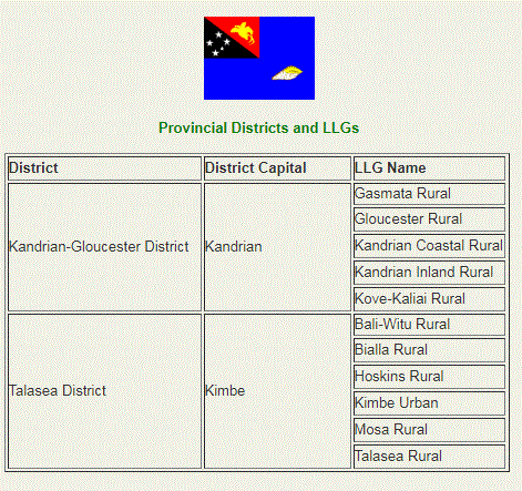 |
AboutOn this page, we provide all the details of the each provinces in PNG. We welcome your critic and contributions. |

- Home
- News
- Business News
- Economy News
- Sports News
- International News
- Corruption News
- Mining Watch
- Jobs
- Education News
- Scholarships
- Health News
- Bzzmart Online Shopping Platform
- Pacific
- Used Cars
- Buy or Rent Homes
-
Travel
- City of Port Moresby
- Adventure and Destination
- Hotels & Lodges in PNG
- Hotels & Lodges in Mendi, Southern Highlands Province
- Hotels & Lodges in Lorengau, Manus Province
- Hotels in Oro Province
- Hotels and Lodges in ESP
- Hotels & Lodges in Kavieng
- Hotels and lodges in Kimbe
- PNG Photo Gallery
- Map of Papua New Guinea
- PNG
-
Computer Tech
- Tech Help
-
Top Weebly designed Websites
>
- HOW TO RECOVER FILES WITH SHORT CUTS OR HIDDEN IN FLASH DRIVE OR EXTERNAL HARD DRIVE
- How to remove Stubborn Computer Virus
- Creating Login or Sign in Membership page in Weebly sites
- How to auto insert Table of Content in Word
- Top Weebly Website Examples and Portfolio
- Weebly Membership Sign in feature available
- Send Free SMS in PNG
- Radio Stations
- Television stations >
- PNG Information Directory
- Computer Resources
- Classifieds
- About us
- Contact Us
- Competition
- Advertisement
- Privacy Policy
- SP PNG Hunters News
- Weebly Forums
- National Football Stadium, Port Moresby
- Work Permits and VISAs in PNG : Guide
- Seasonal Workers Program for PNG
- List Your Business on PNGFacts.com
- Twodot Business Solutions
- Become a Sponsor
- Mt Giluwe Lodge
- Papua New Guinea Defence Force
- Political parties in PNG
- NID PNG
- Employment VISA in PNG
- Business VISA
- Visitor VISA
- Police Clearance in Solomon Islands
- PNG Electoral Commission
- PNG Election Results

 RSS Feed
|
Search Papua New Guinea Database >>
|
|
|
|
|
Home: PNG News :Travel : Government System: Computer Tech : About us: Contact : Disclaimer : Sitemap : Login Copyright & Disclaimer © 2012 -2023 PNG Facts: All rights reserved:
|
Website developed by Kilikalo Technology & Business Solutions Ltd
About |
Terms |
|