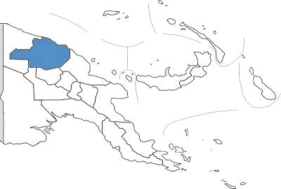
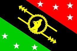
 One of the world's largest waterways, the Sepik, snakes it's way through East Sepik Province. Dense rainforest covers the north coast and the mountains north and south of the river basin. Birdlife and rainforest creatures splash colour across the blue and green hues. Sepik fishermen in their dugout canoes wave to visitors on the great white catainaran, the "Melanesian Explorer", as it plies its way down the river taking passengers on a journey which will impress an unforgettable image of the magnificence of Papua New Guinea. The Sepik River often compared to the Amazon and Congo Rivers presents nature untamed and unspoiled. See it from the comfort of the "Melanesian Discoverer" or the " Sepik Spirit" a luxury twelve berth flat- bottom river cruiser. For the more adventurous, the Karawari Lodge on the Karawari River, south of the Sepik is a quality but very remote jungle tourism lodge, or spend some time in a guest house in the villages along the river. Wewak, with its palm fringed beaches is the main town of East Sepik. Not far from Wewak is Cape Worn, the site of the Japanese surrender where Lieutenant General Adachi signed the surrender documents and handed his sword to Major General Robertson on 13th September 1945. A war memorial marks the site and the wartime airstrip is still in place. Another memorial in town has been erected at the site of the Japanese war graves and nearby is the Japanese/ PNG Peace Park. Accommodation in Wewak, while not luxurious, provides adequate facilities as a base for day trips to one of the 15 islands off the coast of Wewak. Idyllic tropical islands become a reality when you travel by boat to Kairiru Island with its waterfalls and hot springs. Swimming and snorkelling are superb in these clear turquoise waters. Diving is simply spectacular. Virtually unknown and untouched, the waters and reefs display an abundance of sea life - turtles, sharks, manta rays, tuna, corals as well as sunken wrecks from World War 2. Further afield is Wuvulu Island. Acclaimed as one of the greatest dive sites of the world, Wuvulu rises straight up from an undersea plateau 2000 metres deep. As there are no rivers or creeks the water is uncommonly clear. There is a guest house on the island and dive equipment is available. Wet season is April to November. From September to January the unprotected beaches along the coastline bring surf-board riders from around the country and overseas to surf one of PNG's few surf spots. East Sepik's fertile environment is reflected in its rich cultural traditions. Crocodiles, birds, turtles and other wild animals feature in East Sepik artwork. Sepik carvers are world-renowned for their fine craftsmanship. The region's most famous artefacts are the woven fibre ceremonial masks used symbolically in the yam festivals. Jewellery, pottery and canework can be found in the village markets as well as hotel shops around town. Wewak has a pier for overseas and coastal shipping. With 32 airstrips, much of East Sepik is accessible by air and Air Niugini has daily flights from Port Moresby to Wewak. 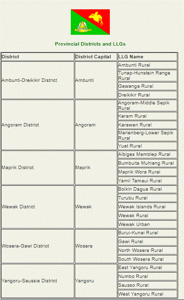 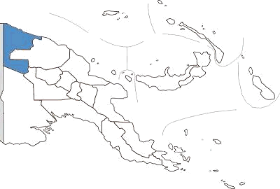 Vanimo, the capital of Sandaun Province, sits on a neat little peninsula with beautiful beaches on either side. A pleasant walk around the headland brings the snorkelling enthusiast to several good spots. To the west, wade past vine draped limestone headlands to reach the final resting place of a rusted Japanese landing barge. Vanimo, 30 kilometres from the Indonesian border is PNG's entry port from Jayapura in Irian jaya (formerly West Papua). This area of the world has seen little development in international tourism, other than visitors enroute from Irian jaya to other parts of Papua New Guinea, or the intrepid traveller or surfer in search of the perfect wave. Superb beaches west of Vanimo, towards Wutung, attract surf board riders from PNG and overseas during the months of September to January. The 260 kilometre shoreline is pounded by heavy seas caused by the blustery north west winds during December to March. However safe all-year round anchorage can be had in Vanimo. Several little islands lie offshore from the town of Aitape, the only other town in Sandaun Province. Aitape was established as a station by the Germans in 1905 and was occupied by the Japanese during World War 2. Bits of aircraft wreckage can be found near the wartime Tadji airstrip and a war memorial stands nearby. The headwaters of the Sepik River are in Sandaun Province. Here the river narrows into dense, mountainous country and only small boats can navigate upstream from the village of Ambunti. There are no roads in the Upper Sepik and much of the province is covered in rainforest. The villages here are known for their specialist religious cults. The people of Maio and Yessan have a yam cult and the isolated village of Swagup is the home of the insect people, whose art form incorporates the figures of the sago beetle, dragonfly, praying mantis and other insects. Among the distinctive artefact, from Sandaun are painted canoe, of Sissano Lagoon and large shields from the Telefomin district. The shields have broad zigzag, spiral or V designs that represent their ancestors' bodies. Vanimo has three hotels, the largest of which is the Sandaun Motel. In other parts of the Province village accommodation is available and some mission stations also offer simple accommodation. Air Niugini flies to Vanimo weekly en route to jayapura, Irian Jaya. 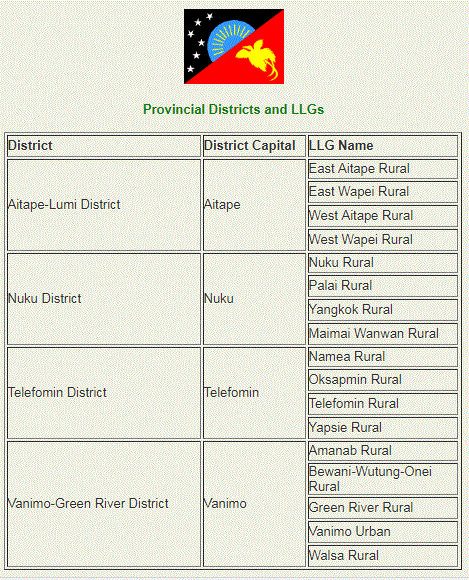 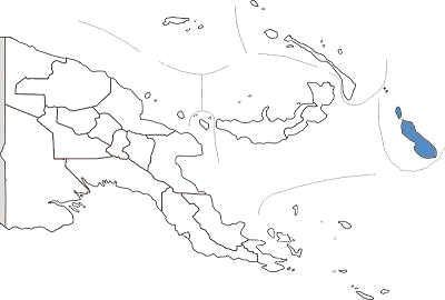 Bougainville is situated about 5 degrees south of the equator and is hot. Bougainville is going through a time of rapid change. Since the signing of the peace agreement in 2001 development agencies have been working on various projects from agriculture to business to improving health, education to name a few. North Solomons Province has two main islands, Buka and Bougainville plus a scattering of smaller islands and atolls. It is located north east of mainland Papua New Guinea. Blessed with a lovely French name shares with an explorer and one of the Pacific most beautiful plants, Bougainville is a jewel of the South Seas. And while a decade of disturbance has wilted the memories of some, the island is being reborn, and the business centre of Buka is booming. The North Solomons Province has been known for its picture-perfect beaches and bays since French explorers spread the stories of its beauty almost 200 years ago. The influence of the French is still found in the Polynesian languages spoken on the Takuu and Nukumanu islands. In fact 23 languages are spoken throughout the province. Almost a decade of civil war left only the language of violence until recently on the island of Bougainville. Now the fighting is finished and the lovely island of Bougainville is flourishing. Air Niugini can take you from Port Moresby to Buka three times a week aboard the swift and comfortable F28 jet services. Flights are scheduled for Tuesday, Thursday and Saturday, with the aircraft returning the same days. Number of guest house and a small island resort provide and, along with the market, a good range of shops will keep shoppers happy. Cafes and coffee shops make deliciously good use of local produce new the brand new hospital. Whether snorkeling or SCUBA diving, the waters off the coast are a treasure cove. A Visibility is almost unlimited, with wartime wrecks including a Japanese Zero aircraft only a few meters deep. The crafts and customs of Buka and North Bougainville are fascinating for anyone interested in the culture. Featured on the provincial flag is a tall hat, known as Upei. The Upei is a woven headdress worn by young men at their initiation and marriage ceremonies. Buka is the provincial capital. Shops and services for the town are located along the main waterfront, including the market and water taxis. Sohano Island is just a few minutes by boat from Buka, with its colonial buildings and manicured lawns and gardens. The steep cliffs provide fine views over Buka Passage and there are good swimming beaches. The volcanic island of Bougainville is covered in heavy jungle, and is home to one of the world's largest caves, Benua. The island's highest point is Mount Balbi (2685m), a dormant volcano. While roads, including the main road down to the east coast, are still being re-built, coastal shipping is still thriving between Buka and Kieta, near Arawa in the south. 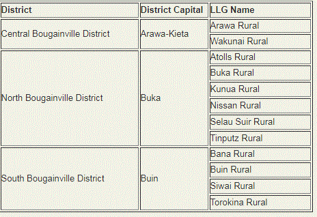 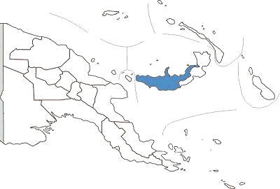 In contrast to the popular tourist destination of East New Britain, West New Britain is virtually untouched, unexplored and unknown. The exception is Walindi Plantation Dive Resort, a favourite destination for divers from all parts of the world. The Resort is located on a privately owned oil palm plantation on the shores of Kimbe Bay. The Bay is fringed by volcanic mountains, some still active. Divers can explore volcanic caves draped in staghorn coral and reef drop-offs. The clear blue waters are home to dogtooth tuna, trevally, barracuda, dolphins and dugong and for night diving, the luminescence lights the way. The most popular site for night diving is known as "The Cathedral", a horse shoe shaped reef with a large cave at one end. The floor is covered in white sand and the outside is draped in staghorn and gorgonia coral. Walindi has resident instructors to provide tuition for first time divers. The fishing and snorkelling are excellent. Non-divers can enjoy the superb natural surroundings. The Muruk cave system in the Nakanai area of West New Britain is believed to be the deepest recorded in the southern hemisphere. A French cave expedition team recently explored the system and believe there is a canyon about 1,200 metres below the entrance of the cave. The pretty little town of Talasea looks across the bay with its many islands from Williamez Peninsula, an active volcanic region. Talasea is a centre for the manufacture of shell money. It was from this area that obsidian, volcanic glass used in the manufacture of knives, spears and arrows used for trade from about 3,OOOBC until recent times, was found. In the hills behind Talasea are the wrecks of two US bombers, one of them a B24 Liberator. On Pangula Island, across from Talasea is the Valley of Wabua, meaning "Valley of Hot Water", a mass of thermal geysers. Apart from Walindi Resort there are several other options for accommodation including the Palm Lodge in the provincial headquarters of Kimbe; the Hoskins Hotel in the small town of Hoskins where the main airport'for West New Britain is located; the Kautaga Guest Haus on a small island off the western side of the peninsular and the Bialla Guest House. Air Niugini and a number of third level airlines fly via Hoskins airport from other parts of Papua New Guinea every day. There are also a number of coastal ships which call in at Kimbe on their way to and from Lae and Rabaul. 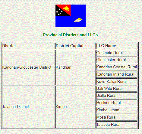 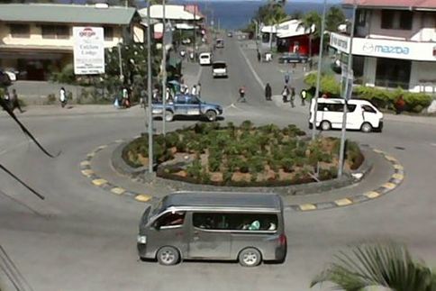 The town of Kokop. Photo by Tufty Oy The town of Kokop. Photo by Tufty Oy East New Britain is a province of Papua New Guinea, consisting of the north-eastern part of the island of New Britain and the Duke of York Islands. Capital City: Kokopo Population : 300 000 est Land area : 15,816 square kilometres (6,107 sq mi) There are sixteen Austronesian languages spoken in the province, of which Kuanua, spoken by the Tolai on the Gazelle Peninsula is the most widely spoken. East New Britain has a dual economy: a cash economy operates side by side with the subsistence-farming sector. The main crops produced for export are cocoa and copra. Tourism continues to be an increasingly important sector of the provincial economy. Districts Each province in Papua New Guinea has one or more districts, and each district has one or more Local Level Government (LLG) areas. For census purposes, the LLG areas are subdivided into wards and those into census units.[2] District 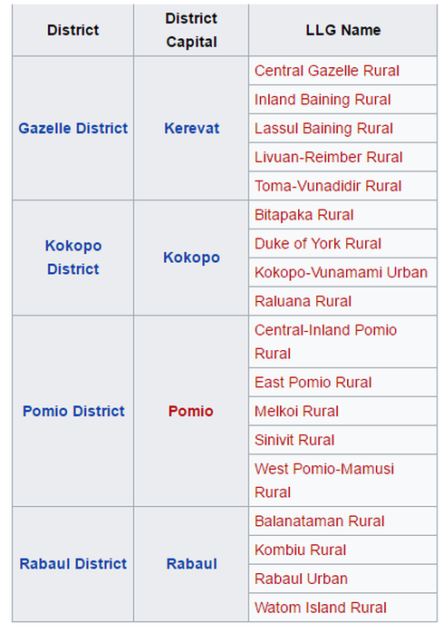  Long, narrow and mountainous, New Ireland boasts undeniable beauty, peaceful people, never ending beaches, the popular Malagan show, the unique annual Shark Calling festival, game fishing and a history visited by explorers, missionaries, traders and Japanese armed forces. Discovered by Dutch explorers in 1516, it was 1877 when the first missionaries arrived. With the development of copra plantations it soon became one of Germany's most profitable colonies. During World War 2, New Ireland fell to the Japanese and many of the island's towns, infrastructure and industry was destroyed. New Ireland was also the setting for the saga of the Marquis de Ray who advertised Cape Breton as a thriving settlement, sold hundred of hectares of land to gullible settlers who were dumped with three weeks supplies, including a mill, note books and bricks, into a tangled jungle, with perpetual rainfall and unfriendly neighbours. Most died of starvation or malaria before being rescued and sent to Australia. Parts of the grinding stone for the never used grain mill can still be found in Kavieng. As for the Marquis de Ray, he ended his days in a lunatic asylum in France. The provincial centre of Kavieng is situated at the northern tip of the island. It has often been described as a "typical Somerset Maughan south sea island port". It has a large, beautiful harbour and is a popular destination for game fishing enthusiasts. Along the edge of the harbour is Kavieng's Harbour Drive, a gently curving road, shaded by huge trees, which passes many points of historical interest. A couple of kilometres out of Kavieng, along the Buluminski Highway, a little pathway leads off the road to a limestone cave filled with crystal clear water. At Utu village, the high school has a small museum with exhibitions of Malagan carvings - carved totem-like poles used in initiation ceremonies and rituals; ancient stone tools and vessels and a shark catching propeller. New Ireland is the centre for the art of shark calling. Certain men have the ability to 'call up" sharks. The unfortunate shark swims up to the caller's boat where they can be speared and netted. Alternatively the shark propeller is used - a noose is hung with half coconut shells which make a rattling noise, attracting the shark up through the noose. A rope attached to the noose is connected to a wooden propeller which is spun round to tighten the noose and simultaneously pull in the rope. The shark, unable to keep moving, effectively drowns. New Ireland Province includes a number of offshore islands. From the northeast coast are the islands of Tabar, Tanga, Feni and Lihir. Lihir Island is the site of the Lihir gold mine, reputed to have the second largest gold deposit in the world. 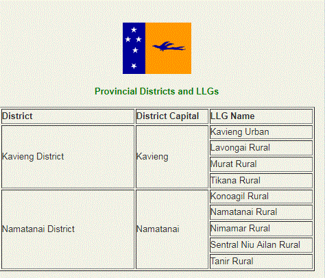 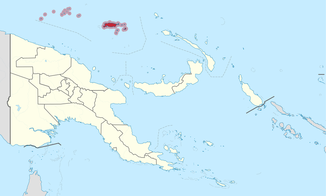 Manus is Papua New Guinea's smallest province, both in terms of landmass and population, but has a vast sea area rich with marine life and beautiful coral reefs.
The province consists of a group of islands, known as the Admiralty Islands and a scattering of low-lying atolls, mostly uninhabited, with the northern border reaching the equator. The reefs near the atolls are accessible by outboard motor or canoe and provide superb diving and fishing. The adventurous and athletic can enjoy sea kayaking, a sport fast becoming popular among the seafaring community of Manus. Sea kayaking tours can range from day trips to a seven-day tour, giving visitors the opportunity to enjoy the marine life, the waterways and the scenery of Manus. Manus, the largest of the islands, is rugged and heavily timbered with central hills rising to over 700 metres and many sharp ridges and streams. The airport is in Momote on Los Negros Island. A good road connects Los Negros to the main town of Lorengau on Manus Island. The islands are connected by a bridge crossing the Loniu Passage. There is a pleasant waterfall and a fresh water pool on the Lorengau River a few kilometres upstream from Lorengau town. During World War 2, Manus was occupied by the Japanese and later by American and Australian armed forces, who spent millions of dollars constructing a huge base, airport and dock facilities at Seeadler Harbour. During wartime activity up to 600 ships anchored in the harbour. Today it is a peaceful place ringed by small islets and a magnificent reef. The rusting remains of the base can still be seen nearby. A variety of hotels, lodge style accommodation and village guest houses are available, including the Lorengau Kohai Lodge, the Andra Guest House and the Harbour Side Hotel, all of which provide comfortable facilities for visitors. District District Capital Manus District Lorengau LLG Name Aua-Wuvulu Rural Balopa Rural Bisikani-Soparibeu Kabin Rural Lelemadih-Bupi Chupei Rural Lorengau Urban Los Negros Rural Nali Sopat-Penabu Rural Nigoherm Rural Pobuma Rural Pomutu-Kurti-Andra Rural Rapatona Rural Tetidu Rural |
AboutOn this page, we provide all the details of the each provinces in PNG. We welcome your critic and contributions. |
- Home
- News
- Business News
- Economy News
- Sports News
- International News
- Corruption News
- Mining Watch
- Jobs
- Education News
- Scholarships
- Health News
- Bzzmart Online Shopping Platform
- Pacific
- Used Cars
- Buy or Rent Homes
-
Travel
- City of Port Moresby
- Adventure and Destination
- Hotels & Lodges in PNG
- Hotels & Lodges in Mendi, Southern Highlands Province
- Hotels & Lodges in Lorengau, Manus Province
- Hotels in Oro Province
- Hotels and Lodges in ESP
- Hotels & Lodges in Kavieng
- Hotels and lodges in Kimbe
- PNG Photo Gallery
- Map of Papua New Guinea
- PNG
-
Computer Tech
- Tech Help
-
Top Weebly designed Websites
>
- HOW TO RECOVER FILES WITH SHORT CUTS OR HIDDEN IN FLASH DRIVE OR EXTERNAL HARD DRIVE
- How to remove Stubborn Computer Virus
- Creating Login or Sign in Membership page in Weebly sites
- How to auto insert Table of Content in Word
- Top Weebly Website Examples and Portfolio
- Weebly Membership Sign in feature available
- Send Free SMS in PNG
- Radio Stations
- Television stations >
- PNG Information Directory
- Computer Resources
- Classifieds
- About us
- Contact Us
- Competition
- Advertisement
- Privacy Policy
- SP PNG Hunters News
- Weebly Forums
- National Football Stadium, Port Moresby
- Work Permits and VISAs in PNG : Guide
- Seasonal Workers Program for PNG
- List Your Business on PNGFacts.com
- Twodot Business Solutions
- Become a Sponsor
- Mt Giluwe Lodge
- Papua New Guinea Defence Force
- Political parties in PNG
- NID PNG
- Employment VISA in PNG
- Business VISA
- Visitor VISA
- Police Clearance in Solomon Islands
- PNG Electoral Commission
- PNG Election Results
 RSS Feed
|
Search Papua New Guinea Database >>
|
|
|
|
|
Home: PNG News :Travel : Government System: Computer Tech : About us: Contact : Disclaimer : Sitemap : Login Copyright & Disclaimer © 2012 -2023 PNG Facts: All rights reserved:
|
Website developed by Kilikalo Technology & Business Solutions Ltd
About |
Terms |
|