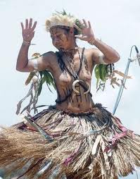
 A dancer from Kairuku district Kairuku-Hiri
General Information Administration District headquarters: Bereina/Konedobu Number of LLGs: 4 - Hiri Rural, Kairuku Rural, Koiari Rural, Mekeo Rural Number of wards: 75 About Kairuku-Hiri Kairuku-Hiri district surrounds Port Moresby and stretches from Gulf Province to Gaire Village, south east of Port Moresby. The inland areas in the Owen Stanley Range include the Sogeri Plateau and the area surrounding the Kokoda Track. Port Moresby markets offer high income-earning opportunities for the sale of food and betel nut, however there is also strong population pressure on the flood plains around Bereina and in the settlement areas north of Port Moresby, with high intensity cultivation being practised on land with a poor potential for agriculture. The most disadvantaged communities are those living along the Kokoda Track. The land surrounding these communities has poor agricultural potential and there is poor access to services. 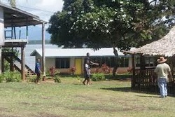 Rigo District
General Information Administration District headquarters: Kwikila Number of LLGs: 3 - Rigo Central Rural, Rigo Coastal Rural, Rigo Inland Rural Number of wards: 67 About Rigo Rigo District is located in the south east of Central Province, and stretches from the coast up into the Owen Stanley Ranges on the border of Oro Province. There are low incomes available from agriculture on the coast, as a long dry season makes the coastal plains unsuitable for intensive agricultural activity. However, many people commute to Port Moresby to earn an income. The most disadvantaged people are those living in the Owen Stanley Ranges who live on land that has a low potential for cultivation and are remote from services. 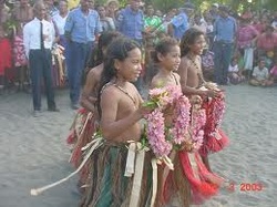 Children in Abau Abau
General Information Administration District headquarters: Abau Number of LLGs: 3 - Amazon Bay Rural, Aroma Rural, Cloudy Bay Rural Number of wards: 40 About Abau Abau district is located in the south east of Central Province. The district covers the coastal areas west of Milne Bay and the mountains and valleys of the Owen Stanley Ranges. There is potential for increased agricultural activities in the coastal plains of the district, especially north of Kupiano, and incomes are high from food sales in the Cape Rodney land settlement area. However, the population living in the coastal swamps and in isolated mountain areas earn low incomes from food, fishing, betel nut, coconut and coffee. The land in these areas has poor agricultural potential. 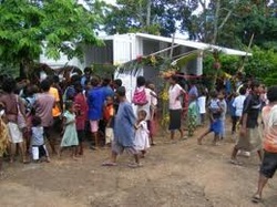 Taipini Station Goilala District
General Information Administration District headquarters: Tapini Number of LLGs: 3 - Guari Rural, Tapini Rural, Woitape Rural Number of wards: 23 About Goilala Goilala District is located in the northern inland area of Central Province, bordering both Morobe and Oro Provinces, and covers the mountains and valleys of the Owen Stanley Ranges. Incomes are moderate and agricultural potential is high in the lower valleys where transportation to markets is available. The upper valleys have low incomes and low agricultural potential because of their steep slopes and poor weather conditions. There is a gold mining operation at Tolukuma, north of Woitape, however, it has little influence on the incomes of the rural population
 About Western Highlands
Western Highlands Province covers the Jimi, Wahgi, Baiyer, Lai, Kaugel and Nebilyer Valleys. It also includes the Hagen Range, the Kubor Range and the mountains of the Sepik-Wahgi Divide which run through the entire province. The provincial member declared elected in 2007 was Mr. Tom Olga of the National Alliance Party. The sitting member between 2002 and 2007 was one-time Prime Minister, Mr. Paias Wingti. Western Highlands Province has some of the most productive smallholder agriculture and coffee plantations in PNG. People in the Wahgi, Baiyer and Nebilyer Valleys earn high incomes from the sale of coffee and food. However, the more remote lower Jimi Valley and Mera area earn much lower incomes. Wage employment is also available in the township of Mt Hagen. The Highlands Highway runs through the Wahgi and Nebilyer Valleys. Other smaller road networks travel through the Tambul Nebilyer, Baiyer Mul and Jimi Districts. However, people in the far north, in the lower Jimi Valley and far south near Mera are isolated from service centres. Administration Provincial headquarters: Mt. Hagen Number of districts: 7 - Anglimp South Wahgi, Baiyer Mul , Dei, Hagen, Jimi, North Wahgi, Tambul Nebilyer Number of LLGs: 15 Number of wards: 479 Area and population density Area (km²) 9097 Occupied area (km²) 4375 Population per km² 48.4 Population per km² of occupied area 100.6 Population Total
Split to create Jiwaka ProvinceIn July 2009, Parliament passed legislation to create two new provinces by 2012. One of these was to be created by removing Jimi District, North Waghi District, and the South Waghi part of Anglimp-South Waghi District from the Western Highlands Province to form the new Jiwaka Province. "Jiwaka" is a portanteau word combining the first two letters each of Jimi, Waghi and Kambia. Jiwaka Province officially came into being on 17 May 2012. EconomyThe Western Highlands economy is primarily based on coffee. Coffee is grown on plantations and small-holder blocks. They are picked, dried and processed for export. In addition, tea is also a major crop grown and processed, but in plantations by Wr Carpenters & Company Limited for local consumption and export. Apart from these, vegetables are grown for the domestic market, and sold mainly to markets Lae and Port Moresby. Districts and LLGs Each province in Papua New Guinea has one or more districts, and each district has one or more Local Level Government (LLG) areas. For census purposes, the LLG areas are subdivided into wards and those into census units. DistrictDistrict CapitalLLG Name Dei DistrictDei
Mt. Hagen DistrictMt. Hagen
Mul-Baiyer DistrictBaiyer
Nebilyer DistrictNebilyer
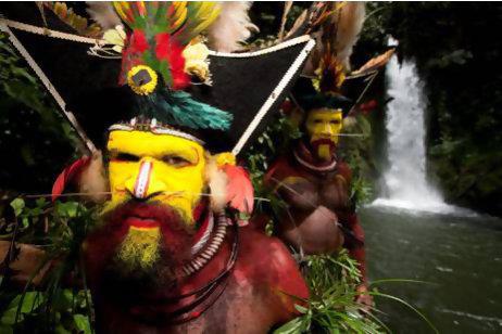 Thousands of Tourists visit Hela Province every year to see Hela Wigmen
|
 | Country: Papua New Guinea Capital Mendi Government - Governor: William Powi (2012) Area - Total: 9,189.2 sq mi (23,800 km2) Population (2012) - Total: 646,265 - Density 59.4/sq mi (23/km2) |
Southern Highlands: According to Papua New Guinea's national 2000 census, the total population of Southern Highlands is 546,265 spread across 23,800 square kilometers (9,189 square miles), which makes it the most highly populated province in the country.
Split to create Hela Province
In July 2009, Parliament passed legislation to create two new provinces by 2012. One of these is to be created by removing the districts of Tari-Pori, Komo-Magarima, and Koroba-Kopiago from the Southern Highlands Province to form the new Hela Province.[1]
Split to create Hela Province
In July 2009, Parliament passed legislation to create two new provinces by 2012. One of these is to be created by removing the districts of Tari-Pori, Komo-Magarima, and Koroba-Kopiago from the Southern Highlands Province to form the new Hela Province.[1]
About ENGA
Enga is one of the seven Highlands Provinces in Papua New Guinea. One unique thing about Enga province is that all inhabitants of Enga speak one language unlike other provinces.
Districts : Kandep, Kompiam, , Lagaip-Porgera, Wabag
Capital
Wabag
Government
Governor - Hon. Peter Ipatas (2012)
Provincial Administrator - Dr. Samson Amean
Provincial Treasurer - Mr. Joe Warapio
Area Total
11,704 km2 (4,519 sq mi)
Population Total
432,045
Density
37/km2 (96/sq mi)
Enga Province is located in the north most region of the highlands of PNG, having been divided from the Western Highlands to become a separate province when the provinces were created at the time of independence in 1975. The people of Enga are called Engans—they are a majority ethnic group—speaking one language in all its five districts: approximately 500,000 people.
Enga is unique among the provinces in Papua New Guinea in that it has only one major linguistic and ethnic group: Enga speakers. Although dialects of the Enga language vary greatly from Laiagam in the west to Wapenamanda in the east, Engans' shared ethnic identity overshadows the existence of other ethnic groups in the province, such as Ipili speakers (around Porgera) and Nete speakers.
Districts and LLGs
Each province in Papua New Guinea has one or more districts, and each district has one or more Local Level Government (LLG) areas. For census purposes, the LLG areas are subdivided into wards and those into census units.
District District Capital LLG Name
Kandep District Kandep - Kandep Rural
- Wage Rural
Kompiam District Kompiam Ambum Rural
Kompiam Rural
Wapi (Uangis) Rural
Lagaip-Pogera District Laiagam-Porgera Pilikambi Rural
Maip-Mulitaka Rural
Paiela-Hewa Rural
Porgera Rural
Wapenamanda District Wapenamanda Wapenamanda Rural
Tsak Rural
Wabag District Wabag
Maramuni Rural
Wabag Rural
Wabag Urban
Jiwaka is a province of Papua New Guinea. The provincial capital is yet to be decided. In the mean time all provincial matters are handled in Banz. The province covers an area of 4,798 km²,[2] and there are 341,928 inhabitants (2010 census provisional figures[3]—2000 census 185,641). Jiwaka province officially came into being on 17 May 2012,[4] comprising three districts [5][6]previously part of Western Highlands Province. Mount Wilhelm, the tallest mountain in Papua New Guinea, is on the border of Jiwaka.
"Jiwaka" is a portmanteau word combining the first two letters each of Jimi, Wahgi and Kambia. The inclusion of the Anglimp Rural LLG in Jiwaka was controversial,[7] and will be reviewed after the 2012 General Election.
Districts
Anglimp-South Waghi District
Jimi District
North Waghi District
Capital
Barns
Government
Governor - Dr. William Tongamp
Provincial Administrator-
Provincial Treasurer -
Area Total
4,798 km2 (1,853 sq mi)
Population Total
343,987
Density
72/km2 (190/sq mi)
Districts and LLGs
There are three districts in the province. Each district has one or more Local Level Government (LLG) areas. For census purposes, the LLG areas are subdivided into wards and those into census units
About
On this page, we provide all the details of the each provinces in PNG. We welcome your critic and contributions.
 RSS Feed