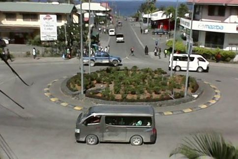
 The town of Kokop. Photo by Tufty Oy The town of Kokop. Photo by Tufty Oy East New Britain is a province of Papua New Guinea, consisting of the north-eastern part of the island of New Britain and the Duke of York Islands. Capital City: Kokopo Population : 300 000 est Land area : 15,816 square kilometres (6,107 sq mi) There are sixteen Austronesian languages spoken in the province, of which Kuanua, spoken by the Tolai on the Gazelle Peninsula is the most widely spoken. East New Britain has a dual economy: a cash economy operates side by side with the subsistence-farming sector. The main crops produced for export are cocoa and copra. Tourism continues to be an increasingly important sector of the provincial economy. Districts Each province in Papua New Guinea has one or more districts, and each district has one or more Local Level Government (LLG) areas. For census purposes, the LLG areas are subdivided into wards and those into census units.[2] District 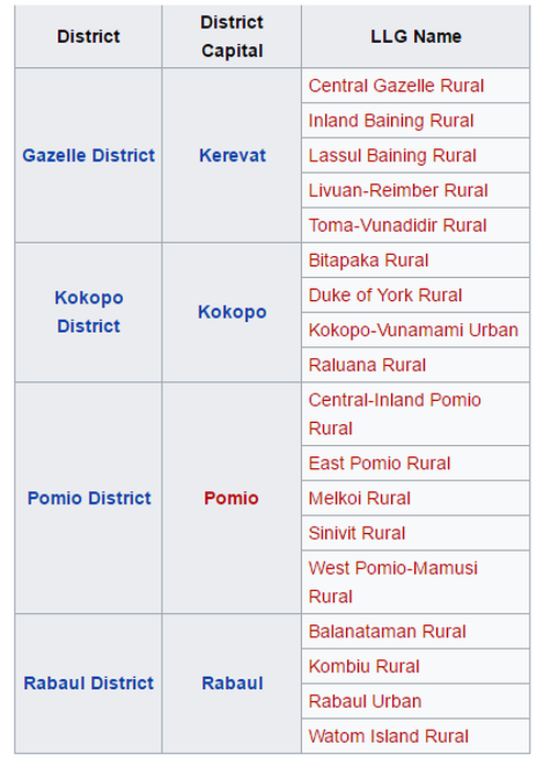  Long, narrow and mountainous, New Ireland boasts undeniable beauty, peaceful people, never ending beaches, the popular Malagan show, the unique annual Shark Calling festival, game fishing and a history visited by explorers, missionaries, traders and Japanese armed forces. Discovered by Dutch explorers in 1516, it was 1877 when the first missionaries arrived. With the development of copra plantations it soon became one of Germany's most profitable colonies. During World War 2, New Ireland fell to the Japanese and many of the island's towns, infrastructure and industry was destroyed. New Ireland was also the setting for the saga of the Marquis de Ray who advertised Cape Breton as a thriving settlement, sold hundred of hectares of land to gullible settlers who were dumped with three weeks supplies, including a mill, note books and bricks, into a tangled jungle, with perpetual rainfall and unfriendly neighbours. Most died of starvation or malaria before being rescued and sent to Australia. Parts of the grinding stone for the never used grain mill can still be found in Kavieng. As for the Marquis de Ray, he ended his days in a lunatic asylum in France. The provincial centre of Kavieng is situated at the northern tip of the island. It has often been described as a "typical Somerset Maughan south sea island port". It has a large, beautiful harbour and is a popular destination for game fishing enthusiasts. Along the edge of the harbour is Kavieng's Harbour Drive, a gently curving road, shaded by huge trees, which passes many points of historical interest. A couple of kilometres out of Kavieng, along the Buluminski Highway, a little pathway leads off the road to a limestone cave filled with crystal clear water. At Utu village, the high school has a small museum with exhibitions of Malagan carvings - carved totem-like poles used in initiation ceremonies and rituals; ancient stone tools and vessels and a shark catching propeller. New Ireland is the centre for the art of shark calling. Certain men have the ability to 'call up" sharks. The unfortunate shark swims up to the caller's boat where they can be speared and netted. Alternatively the shark propeller is used - a noose is hung with half coconut shells which make a rattling noise, attracting the shark up through the noose. A rope attached to the noose is connected to a wooden propeller which is spun round to tighten the noose and simultaneously pull in the rope. The shark, unable to keep moving, effectively drowns. New Ireland Province includes a number of offshore islands. From the northeast coast are the islands of Tabar, Tanga, Feni and Lihir. Lihir Island is the site of the Lihir gold mine, reputed to have the second largest gold deposit in the world. 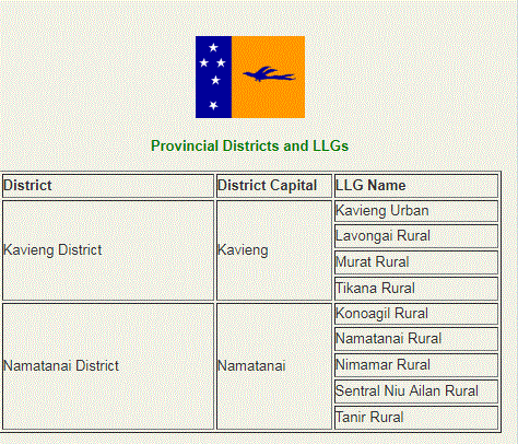 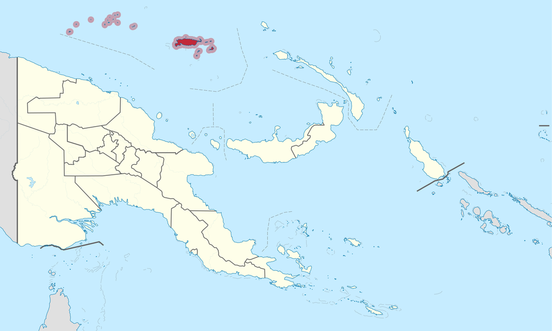 Manus is Papua New Guinea's smallest province, both in terms of landmass and population, but has a vast sea area rich with marine life and beautiful coral reefs.
The province consists of a group of islands, known as the Admiralty Islands and a scattering of low-lying atolls, mostly uninhabited, with the northern border reaching the equator. The reefs near the atolls are accessible by outboard motor or canoe and provide superb diving and fishing. The adventurous and athletic can enjoy sea kayaking, a sport fast becoming popular among the seafaring community of Manus. Sea kayaking tours can range from day trips to a seven-day tour, giving visitors the opportunity to enjoy the marine life, the waterways and the scenery of Manus. Manus, the largest of the islands, is rugged and heavily timbered with central hills rising to over 700 metres and many sharp ridges and streams. The airport is in Momote on Los Negros Island. A good road connects Los Negros to the main town of Lorengau on Manus Island. The islands are connected by a bridge crossing the Loniu Passage. There is a pleasant waterfall and a fresh water pool on the Lorengau River a few kilometres upstream from Lorengau town. During World War 2, Manus was occupied by the Japanese and later by American and Australian armed forces, who spent millions of dollars constructing a huge base, airport and dock facilities at Seeadler Harbour. During wartime activity up to 600 ships anchored in the harbour. Today it is a peaceful place ringed by small islets and a magnificent reef. The rusting remains of the base can still be seen nearby. A variety of hotels, lodge style accommodation and village guest houses are available, including the Lorengau Kohai Lodge, the Andra Guest House and the Harbour Side Hotel, all of which provide comfortable facilities for visitors. District District Capital Manus District Lorengau LLG Name Aua-Wuvulu Rural Balopa Rural Bisikani-Soparibeu Kabin Rural Lelemadih-Bupi Chupei Rural Lorengau Urban Los Negros Rural Nali Sopat-Penabu Rural Nigoherm Rural Pobuma Rural Pomutu-Kurti-Andra Rural Rapatona Rural Tetidu Rural |
AboutOn this page, we provide all the details of the each provinces in PNG. We welcome your critic and contributions. |
- Home
- News
- Business News
- Economy News
- Sports News
- International News
- Corruption News
- Mining Watch
- Jobs
- Education News
- Scholarships
- Health News
- Bzzmart Online Shopping Platform
- Pacific
- Used Cars
- Buy or Rent Homes
-
Travel
- City of Port Moresby
- Adventure and Destination
- Hotels & Lodges in PNG
- Hotels & Lodges in Mendi, Southern Highlands Province
- Hotels & Lodges in Lorengau, Manus Province
- Hotels in Oro Province
- Hotels and Lodges in ESP
- Hotels & Lodges in Kavieng
- Hotels and lodges in Kimbe
- PNG Photo Gallery
- Map of Papua New Guinea
- PNG
-
Computer Tech
- Tech Help
-
Top Weebly designed Websites
>
- HOW TO RECOVER FILES WITH SHORT CUTS OR HIDDEN IN FLASH DRIVE OR EXTERNAL HARD DRIVE
- How to remove Stubborn Computer Virus
- Creating Login or Sign in Membership page in Weebly sites
- How to auto insert Table of Content in Word
- Top Weebly Website Examples and Portfolio
- Weebly Membership Sign in feature available
- Send Free SMS in PNG
- Radio Stations
- Television stations >
- PNG Information Directory
- Computer Resources
- Classifieds
- About us
- Contact Us
- Competition
- Advertisement
- Privacy Policy
- SP PNG Hunters News
- Weebly Forums
- National Football Stadium, Port Moresby
- Work Permits and VISAs in PNG : Guide
- Seasonal Workers Program for PNG
- List Your Business on PNGFacts.com
- Twodot Business Solutions
- Become a Sponsor
- Mt Giluwe Lodge
- Papua New Guinea Defence Force
- Political parties in PNG
- NID PNG
- Employment VISA in PNG
- Business VISA
- Visitor VISA
- Police Clearance in Solomon Islands
- PNG Electoral Commission
- PNG Election Results
 RSS Feed
|
Search Papua New Guinea Database >>
|
|
|
|
|
Home: PNG News :Travel : Government System: Computer Tech : About us: Contact : Disclaimer : Sitemap : Login Copyright & Disclaimer © 2012 -2023 PNG Facts: All rights reserved:
|
Website developed by Kilikalo Technology & Business Solutions Ltd
About |
Terms |
|